نظام الملاحة Geotrack Explorer Plus GPS/GNSS لـ جرار بعجلات


إذا قررت شراء المعدات بسعر منخفض، فتأكد أنك تتواصل مع البائع الحقيقي. اكتشف أكبر قدر ممكن من المعلومات عن مالك المعدات. تتمثل إحدى طرق الغش في تقديم نفسك كشركة حقيقية. إن ساورك شك، أخبرنا عن ذلك من أجل تشديد الرقابة وذلك من خلال نموذج التعليقات.
قبل أن تقرر القيام بالشراء، احرص على مراجعة العديد من عروض البيع بعناية لفهم متوسط تكلفة المعدات التي اخترتها. إذا كان سعر العرض الذي أعجبك أقل بكثير من عروض مشابهة، ففكر في الأمر بتأنٍ. قد يكون هناك فرق أسعار هائل يشير إلى عيوب مخفية أو أن البائع يحاول ارتكاب أعمال احتيالية.
ابتعد عن شراء المنتجات التي يكون سعرها مختلف بشدة عن متوسط السعر لمعدات مشابهة.
لا توافق على الوعود المثيرة للشكوك والبضائع المدفوعة مسبقًا. إن ساورك شك، فلا تخاف من طلب توضيح التفاصيل وأن تطلب صورًا ومستندات إضافية للمعدات وأن تفحص صحة التصديق على تلك المستندات وتطرح الأسئلة التي تساورك.
أكثر أنواع الاحتيال شيوعًا، قد يطلب البائعون غير المنصفون مبلغًا معينًا كعربون مسبق "لتحجز" حقك في شراء المعدات. وبالتالي يستطيع المحتالون تجميع مبلغًا ضخمًا ثم يختفون ولا تستطيع التواصل معهم بعد ذلك.
- إرسال الدفعة المسبقة إلى البطاقة
- لا تقم بالدفع المسبق بدون مستندات ورقية تؤكد عملية تحويل الأمول إذا ساورك أي شك في البائع خلال التواصل.
- إرسال إلى حساب "الوصي" “Trustee”
- هذا الطلب ينبغي أن يكون بمثابه إنذار فأنت على الأرجح تتواصل مع شخص محتال.
- إرسال إلى حساب الشركة باسم مشابه
- توخّ الحذر، فقد يختفي المحتالون أنفسهم أيضًا خلف شركات معلومة أو يدخلون تغييرات طفيفة على الاسم. لا تحول الأموال إذا ساورك شك في اسم الشركة.
- استبدال البيانات الخاصة في فاتورة شركة حقيقية
- قبل التحويل، تأكد أن البيانات المحددة صحيحة وأنها ترتبط أو لا ترتبط بالشركة المحددة.
معلومات الاتصال بالبائع


 أوكرانيا


AGRICULTURAL GUIDANCE SYSTEM WITH A WIDE SET OF FUNCTIONS AND STABLE ACCURACY USING A FREE SATELLITE SIGNAL. SUPPORT FOR AUTOMATIC SPRAYER SECTION CONTROL. PROFESSIONAL RTK MODE WITH ACCURACY UP TO 2.5 cm.
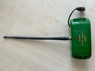
Forget about the lack of a satellite signal while working and stopping field work. With the new and state-of-the-art GM SMART GNSS receiver, your navigation system for agricultural machinery will always be up and running. Thanks to simultaneous work with satellite systems GPS, GLONASS, GALILEO, BEIDOU you will always have enough satellites for uninterrupted work in the field. The average number of satellites in operation - 35-40 satellites.
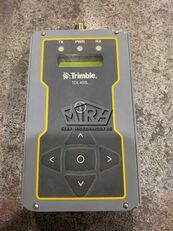
The geotrack explorer PLUS has embedded "GEOTRACK" software, which provides accuracy of 15 cm from pass-to-pass, and the ability to connect to RTK and obtain an accuracy of 1-3 cm. Geotrack explorer PLUS display has a shockproof enclosure, and a completely sealed monitor from dust and moisture.
Using the navigation system for agricultural machinery will allow you to easily solve a number of problems, including: accurate control of machinery in the field, measurement of agricultural land, reducing the number of workers for field work, the ability to work in poor visibility (night, fog, dust); saving time, significantly reducing the cost of fuel, fertilizers, plant protection products and herbicides. During operation, the tips on the screen of the navigation system help to ensure accurate driving, preventing the appearance of untreated areas (flaws) and areas of double treatment (overlaps).
The GeoTrek Explorer PLUS navigation system has a 7-inch (17.8 cm) high-brightness screen that is easy to read even on a bright sunny day. High screen resolution allows you to see a clearer picture. Visual night mode is provided. The display has shock protection and is protected from dust and moisture. The set includes a reliable vibration-resistant metal RAM mount and a docking station.
Equipment:
Rugged monitor geotrack explorer plus 7" (17,8 cm)
GNSS/RTK receiver GM Smart
Docking station with RS232
RAM mount
Cables
User manual, warranty card and other documents
Strength characteristics:
Dust and moisture protection: IP67
Vibration resistance consistency: MIL-STD-810G
Gravity drop resistance test: 150 cm
Functionality:
Accurate guidance from pass-to-pass
Accurate area measurement
Treatment of saved fields
Determining the treated area
Visualization of the treated area
Displaying the movement speed
Displaying azimuth
Five guidance patterns
Adjustment of width of equipment (to centimeters)
Online technical support
Saving a field map
Automatic saving works
Specifying Job Types (sowing, spraying, etc.)
Support for RTK L1
Optional support for RTK L1/L2
Online sync with Agroprofile
Operating modes:
Area measurement
Area measurement with offset
Free guidance mode
Straight A-B
Curve A-B
Perimeter - Straight A-B
Perimeter - Curve A-B
Cloud opportunities:
Synchronization of field areas
Synchronization of scheduled works
Displaying works on the map
Online view of performing works in the fields
Entering the types of work
Quality control of works (% of overlapping)
Time spent doing work
What data is displayed while driving:
Treated area
Travelled length
Speed of movement
Number of satellites
Satellite signal quality (HDOP)
Visual guidance tips
Calculation of working time
Count overlapping
Visualization of overlapping
Ratio: work done / in process
Supported languages: English, Italian, French, German, Spanish, Portuguese, Estonian, Ukrainian, Russian, Polish, Hungarian, Hindi, Arabian
Product page: إظهار قائمة الأسماء